The soft afternoon sun has slightly eased the summer heat. All around is an open expanse—Sitakunda’s hills lie to the east, and the waters of the Meghna River stretch to the west. Not a sign of human habitation in sight, not even animals or birds. The silence of this wilderness is broken only by the whistling wind. Following a path through the newly emerged char (sandbank) from the Meghna River, one encounters a barren land—white salt crusts on the soil, patches of grass, and unnamed bushes. Narrow canals flow with water in some places. As one moves toward Sandwip, vegetation increases, along with herds of buffalo. In the distance, enclosures prepared for livestock farming come into view.
On this barren land, Zaher Uddin and his cousin Md Sadikul are busy building homes. About 30 years ago, their houses in this very location were washed away by Meghna’s erosion. The whole family then relocated to Lakshmir Char in Noakhali. A couple of months ago, hearing the news of a new char forming, they returned.
Zahiruddin said, “We have some relatives here; we heard from them that new land had emerged. Then we gathered our implements and slowly made our way back here. We found around 80 acres of land. Our family is large, so we have taken such a huge land.”
In Lakshmir Char, several families, including theirs, had lived on only two acres of land. With the news of this newly formed char, many others like them are arriving at what is now being called the ‘Shobuj Char (Green Char),’ which is located near the Meghna estuary in Sandwip. Covering an area of about 80 square kilometers, more than half of it remains barren. In some areas, livestock grazing and limited farming are taking place. People like Zahiruddin are now trying to reclaim a place they once called home on this fresh land.
Three islands merge
Across the vast southeastern region of the country, a new tale is emerging—of new land and new settlements. This is not merely the story of people displaced by river erosion; it marks the birth of new land in Bangladesh’s history, new economic opportunities, and a convergence of natural and scientific phenomena.
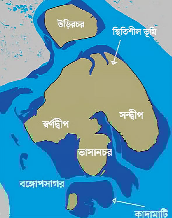
For the past three decades, Sandwip, Jahajjar Char (now known as Swarnadwip), and Bhasan Char—three separate islands—have been gradually joining together. Research from the Bangladesh Space Research and Remote Sensing Organization (SPARRSO) illustrates this process. The formation of new land has led to this transformation.
Economist Hossain Zillur Rahman sees this development as an exceptional and hopeful sign amid the risks posed by climate change. He remarked, “The continuous stream of data we receive about Bangladesh’s vulnerability to climate change is well-known, but SPARRSO’s research provides a unique and alternative narrative. While global forecasts of climate change predict considerable risk, our local knowledge suggests that it’s not just about erosion or submerged plains—there is hope too. This research reflects that local knowledge.”
Three islands becoming one
Sandwip is an ancient island in the Bay of Bengal, identified in SPARRSO’s research as being over 3,000 years old. It has long experienced processes of erosion and sediment deposition. Research shows that between 1989 and 2025, two other islands—Jahajjar Char (now Swarnadwip) and Bhasan Char—have emerged near Sandwip.
This isn’t just silt, it’s a national question paper. How we value our rivers, land, and people will determine whether this potential becomes a tale of prosperity or of exploitation. It’s a test of our policy, science, imagination, and courage. If we get it right, it may fulfil the dreams of countless people.Economist Hossain Zillur Rahman
In 2006, sediment accumulation at the Meghna estuary led to the formation of Bhasan Char. The government of Bangladesh has since constructed housing and cyclone shelters there to relocate Rohingya refugees.
Mahmudur Rahman, a board member of SPARRSO, said that Sandwip, Swarnadwip (Jahajjar Char), and Bhasan Char have now become almost a single landmass. In other words, these three islands are now geographically almost connected. However, since the islands of the Meghna estuary are highly dynamic, continuous monitoring and long-term observation are essential.
The research shows that the coastal geography, particularly the southern part of the Meghna estuary, has seen a highly dynamic history of island formation and expansion between 1989 and 2025. While Sandwip is an ancient island, Swarnadwip and Bhasan Char are relatively new and have expanded steadily due to ongoing sediment deposition.
Bangladesh’s land type and merging of 3 islands
Bangladesh’s landform can broadly be divided into three categories: hilly areas (12 per cent), upland terraces (8 per cent), and alluvial plains (80 per cent). The country has largely been formed through the accumulation of vast quantities of silt carried by major rivers. Most of this silt is deposited in the sea, while some settles and gradually forms land.
The flow and deposition of silt differ across the country’s coastal regions. In the south-western coastal belt, particularly around Khulna, land formation is relatively slow. This is due to the presence of the ‘Swatch of No Ground’, one of the world’s largest underwater canyons in the Bay of Bengal, where a huge volume of silt settles irretrievably.
Additionally, the upstream flow of many rivers in this region has declined, impeding the natural delivery of sediment.
In contrast, the Meghna estuary exhibits a different pattern. Although a large quantity of silt does reach the sea, a significant portion of it contributes to the creation of new land.
Researchers attribute this land emergence to the natural features of the area. New islands are forming around Bhola, Sandwip, and Monpura and are even beginning to merge. This transformation is the result of decades of silt accumulation.
Commenting on the merging of three islands, Professor Kazi Matin Uddin Ahmed from the Department of Geology at the University of Dhaka said, “Whole Bangladesh is formed of alluvial soil. However, the unification of three islands is certainly new information, but land accretion has been occurring rapidly in this region for at least four decades. The emergence of land around Sandwip is a positive development.”
Habitability of the new land
Experts suggest that people should not settle on any new land until at least 20 years have passed since its formation.
Ameer Md. Zahid, Chief Scientific Officer of the Soil Resource Development Institute (SRDI), said: “Initially, we recommend afforestation in these areas. Many chars are used as grazing land. However, there’s never any guarantee that such land, especially in riverine or estuarine zones, won’t disappear suddenly. In some cases, villages have vanished even after 50 years.”
He cited the example of Charbhadrasan in Faridpur, where severe erosion occurred even after five decades. Regarding the newly formed chars around Sandwip, he warned against hasty settlement. Moreover, there’s no certainty that these areas will be habitable even after a long time. The cycle of erosion and accretion is an inherent feature of the region and must be considered.
Ownership disputes and potential
Generally, a diara survey is carried out when new land emerges along rivers or coastlines. This process redefines property boundaries and ownership in light of newly emerged (or lost) land. However, no such survey has yet been proposed for the chars around Sandwip, according to the Upazila Nirbahi Officer (UNO), Mangcingnu Marma.
“I took charge in July. As far as I know, no proposal for a survey has yet been submitted. But it is essential. I will speak with the district administration and send a proposal if permitted,” he told Prothom Alo.
His predecessor, Reagan Chakma, who served as UNO for 18 months, also confirmed that no such proposal had been sent during his tenure.
According to the Shikasti-Poisti law, if land is lost to river erosion (shikasti) and later re-emerges (poisti), under certain conditions the original owner is entitled to reclaim ownership. The Survey and Sairat Wing of the land ministry oversees such matters. However, Saima Yunus, Additional Secretary of the wing, stated that no plan of surveying those newly emerged chars has yet been made.
Though the land has not been distributed formally following the law, many locals, especially those previously displaced by river erosion, have returned here, cultivating crops and beginning to settle.
Some have built temporary shelters using water hyacinths; others have fenced plots with bamboo or prepared livestock pens. Unlike in many parts of the country where new land triggers fierce disputes, Sandwip has so far remained relatively peaceful.
Although no major clashes over new land have been reported in the past 30 years, recent activity has sparked concerns. A few weeks ago, politically influential individuals attempted to seize newly emerged land in Kalapaniya, ousting original landowners. This caused local tensions and temporarily halted the attempt.
Such incidents have left original owners fearing future conflict. Though the law allows for temporary government monitoring before formal allocation, in practice, powerful land grabbers often manage to acquire such land.
Why this research matters
The Sandwip and Meghna estuary region lies within the Ganges-Brahmaputra-Meghna (GBM) river system. Each year, more than 1.06 billion tonnes of silt are deposited in the Bay of Bengal, one of the highest sediment discharges into any ocean globally. These huge amounts of deposits accumulate on the continental shelf, forming new land. Over time, these formations may become stable or erode due to tidal activity.
The latest research was conducted by Bangladesh Space Research and Remote Sensing Organization (SPARRSO) board member Mahmudur Rahman.
He notes that Bangladesh’s coastal areas are not static but constantly changing. Regular mapping is essential to understand these shifts and to inform land-use planning and development policy. The study aimed to track the dynamics of island formation and erosion in and around Sandwip since the 1990s.
Research methodology and findings
This research used Landsat satellite imagery from 1989 to 2025, specifically selecting images captured during January–February at low tide. Data were sourced from the US Geological Survey (USGS) and analysed using visual interpretation and digital mapping from Landsat-5 and Landsat-8 images.
The study presents statistical data on landform changes between 1989 and 2025. In 1989, the total stable land area in and around Sandwip was 328 square kilometres. By 2025, this had increased to 726 square kilometres, an expansion of 398 sq km (121 per cent).
Mudflat areas also increased by 77 square kilometres (23 per cent) during this time. In 1989, these areas measured 335 sq km, rising to 413 sq km by 2025. However, not all mudflats became stable land. Some areas transformed into new land, while others were washed away by tides.
New agricultural and economic horizon
Local people consider the vast newly accreted land around the southern, western, and north-western coasts of Sandwip as a gift of nature. Many families in the region have memories of ancestral homes lost to the sea. For them, this land rekindles a profound emotional connection to their heritage.
Abu Yusuf, 80, from Nyamasti Union said he can now see the place of his birth in Bhashanchar from his current home near the embankment. “The feeling is beyond words,” he said.
At a tea stall near the newly formed Sabujchar, several locals, including Shahjahan Ali and Union Member Nizam Uddin, shared stories of losing homes to the sea, only to rebuild on newly formed land.
Though Shahjahan Ali acknowledges the risks, he summed up the local spirit in the Chattogram dialect. “People will build homes. If one is destroyed, we will move and build another.”
While full-scale settlement is yet to occur, these emerging lands have already empowered some of the region’s poorest. Nearly 7,000 families have gained a degree of self-sufficiency through rice farming, fishing, and livestock rearing.
According to Prothom Alo’s investigation, around 4,000 hectares of Sabujchar land near Sandwip now yield about 20,000 tonnes of Aman rice annually, making it one of the country’s largest single rice-producing zones. In the monsoon season, roughly 2,500 tonnes of various sea fish, worth around Tk 1 billion, are harvested from its waters. In the dry season, nearly 30,000 cattle, buffalo, and sheep graze these pastures.
Economist Hossain Zillur Rahman describes the emergence of this land at the southern frontier of Bangladesh as “the birth of a new agricultural world”.
He remarked, “This isn’t just silt, it’s a national question paper. How we value our rivers, land, and people will determine whether this potential becomes a tale of prosperity or of exploitation. It’s a test of our policy, science, imagination, and courage. If we get it right, it may fulfil the dreams of countless people.”