Prothom Alo investigation
“Choked by design”: How small, low bridges killing rivers in Bangladesh
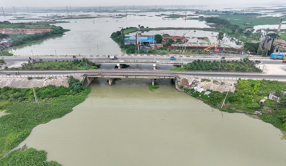
Beyond Aminbazar in Savar, along the Dhaka–Aricha Highway, stands Salehpur Bridge over the Turag River. The approach roads at both ends of the bridge extend far into the river’s boundaries. At the foot of the bridge, the river is struggling to flow through what has become a narrow canal.
On 6 August, a walk along the site revealed that the approach roads encroaching on the river stretched for a total of 160 paces, or approximately 250 feet. This means that at least that much of the river’s width has been filled in across the two ends.
Seen from above through a drone, it looks as though someone has squeezed the river in their fist. The bridge has been shortened to just 59 paces, while silt is accumulating upstream and gradually filling the river. Downstream of the bridge, the river widens again as it flows towards the Buriganga.
Kanu Mia, a resident of Salehpur village, fishes in those waters. Standing on the bank, the elderly man said, “Ever since the bridge was built, the river has become narrower. They have killed the river here with this bridge.”
Signs of the river’s death are clear on one side of the bridge. There, houses and brick kilns have sprung up on land reclaimed from the river, which has been filled with silt and rubbish.
Salehpur is not alone. Across the country, bridge after bridge built without following rules and regulations and by encroaching on rivers has become a noose around rivers’ necks.
AKM Saiful Islam is a professor at the Institute of Water and Flood Management at Bangladesh University of Engineering and Technology (BUET). He told Prothom Alo that when approach roads are extended into a river’s main channel to reduce the length of a bridge, they severely obstruct the flow of water through the narrowed river.
According to him, this causes two kinds of damage. First, silt gets trapped upstream, gradually filling the river. Second, as water rushes through the narrowed section downstream, it erodes the riverbed and causes the banks to collapse.
The expert added that obstructing the natural flow in this way can sometimes effectively kill a river. It also damages the floodplains along its banks and the lives of fish and birds that depend on the river. The main problem is narrowing the rivers to shorten bridges. In addition, poorly planned bridges also damage navigable waterways.
Ever since the bridge was built, the river has become narrower. They have killed the river here with this bridge.Kanu Mia, a resident of Salehpur village
A Prothom Alo investigation has found that many bridges have been built without considering either the life of the river or navigability. Bridges are a source of distress not only for rivers but also for canals. Culverts, like bridges, can also be harmful. Yet no one keeps a complete record of such bridges and culverts, let alone takes steps to address the problem.
Responsibility for building these structures across rivers and canals repeatedly falls on the Local Government Engineering Department (LGED), the Ministry of Disaster Management and Relief, and the Roads and Highways Department (RHD). Political influence is also a factor.
Incomplete records
According to lists published on the websites of the National River Conservation Commission (NRCC) and the Bangladesh Water Development Board (BWDB) in 2025, Bangladesh has 1,415 rivers. However, no figure is available for the number of canals.
In December 2025, the BWDB compiled an incomplete list of infrastructure that obstructs the flow of rivers and canals, along with the agencies responsible for building them.
Prothom Alo obtained the list through an application under the Right to Information Act. It contains information on bridges, culverts, water-control structures such as regulators and sluice gates, embankments, roads and highways, as well as houses and shops.
The incomplete list shows that, among the harmful structures built on 52 rivers and 75 canals across 37 districts, bridges and culverts account for three-quarters of the total.
An executive engineer at the Local Government Engineering Department (LGED) said structures that are generally four metres high and up to eight metres long are classified as culverts. Structures larger than that are considered bridges. Culverts are usually built over drains, he said.
According to the list, there are 193 harmful bridges and culverts on 30 rivers across 20 districts, with bridges accounting for the larger share. Meanwhile, 97 bridges and culverts have been built over 50 canals in 12 districts, with the two types of structures almost equal in number.
River flows decline during winter. Water resources experts say bridge designs have long been based on calculations of river flow during this season. As a result, water drainage is delayed during the monsoon, worsening flooding, said former Bangladesh Water Development Board (BWDB) director general Md Enayet Ullah.
In addition, the NRCC has identified 57 such bridges on three other rivers. Prothom Alo reporters have continued to report on more such bridges at different times.
The BWDB list shows that the highest number of harmful bridges—48—are on the Bhairab River in Jashore and Jhenaidah. There are seven culverts too. The river is in a dying condition.
Prothom Alo’s Jashore correspondent has identified another bridge whose nameplate describes the Bhairab as a ‘canal’. The Kapotaksha River does not appear on the BWDB list. However, the correspondent has found 16 bridges over the river, all but one of which, were built in violation of regulations. These structures are choking the Kapotaksha.
The BWDB list shows that there are 17 harmful bridges on the Narad River in Natore and 16 on the Baral River in the same district. The Swai River, which flows through Mymensingh and Netrokona districts, has 14. On the Ayman River in Mymensingh, there are more culverts than bridges—15 in total. Harmful culverts are on all of these rivers.
The list includes comments from the BWDB’s regional offices on the side of the names of 153 bridges or culverts. Nearly 90 per cent of the comments recommend increasing bridge lengths to match the widths of the rivers. They also recommend raising the bridges.
Low bridges are a major reason why a circular waterway around Dhaka could not become operational. Citing the Bangladesh Inland Water Transport Authority (BIWTA), a Prothom Alo report says there are 20 low bridges along the route, crossing the Buriganga, Turag, Tongi Canal (now recognised as a river), Balu, Shitalakkhya and Dhaleshwari rivers.
Of these, the BWDB list mentions only two bridges over the Tongi River. It does not include any other harmful bridges, including the Salehpur Bridge over the Turag. The NRCC, however, stated in its 2022 annual report that the bridge was shorter than the width of the river.
The same report highlighted how 22 bridges were narrowing the Balu River. At the Nila Market section of Purbachal New Town, it was found that the approach road to one of these bridges had been built inside the boundary marked by BIWTA’s boundary pillars.
The NRCC has also identified 14 harmful bridges on the Kaliganga River in Kushtia.
A bridge every few steps
A total of 21 bridges have been built along a 17-kilometre stretch of the Khakdon River in Barguna district. Meanwhile, three bridges stand within a distance of just 150 yards over the Tangon River in Thakurgaon town.
Most of the bridges over the Khakdon were built by the Local Government Engineering Department (LGED). Of the three over the Tangon, two were built by the Roads and Highways Department (RHD) and one by the LGED. Neither of these examples appears in the BWDB’s 2025 list of harmful infrastructure.
The River Conservation Commission provided Prothom Alo with the figures for the Khakdon. In its 2025 inspection report, the commission said that heavy and coarse silt accumulates in the Tangon and that regular dredging is essential. Erosion, pollution and encroachment are major problems affecting the river.
There is almost no water flow near the three bridges over the Tangon. The BWDB list identifies one vent pipe outlet—a water-control structure—as harmful infrastructure on the river.
Speaking about the Khakdon and Bhairab rivers, Sheikh Md Abu Zakir Sekandar, head of the LGED’s Bridge Design Section said, “The rivers in the areas you are referring to are not particularly wide, so these are certainly all small bridges. If the rivers were larger, so many bridges would not have been built.”
Meanwhile, a senior LGED official, speaking to Prothom Alo on condition of anonymity, said the department had been forced to build bridges measuring 15, 20 and 30 metres under pressure from political leaders. When the pressure is intense, there is no way to refuse, the official said.
Another example of a poorly planned bridge was reported by Prothom Alo’s Kushtia correspondent. The Ministry of Disaster Management and Relief built it over the Kaliganga River in the Shalghar Madhua area of Kumarkhali upazila, Kushtia, around 12 years ago.
On paper, the river is 110 metres wide. However, it has narrowed as it has gradually filled up. Obstructing its flow, a dilapidated bridge measuring around 11 metres stands across the remaining stretch of water strewn with bushes and plants. There are no approach roads on either side, and the bridge is not in use.
A senior LGED official, speaking to Prothom Alo on condition of anonymity, said the department had been forced to build bridges measuring 15, 20 and 30 metres under pressure from political leaders. When the pressure is intense, there is no way to refuse, the official said.
LGED tops the list
According to the BWDB list, the Local Government Engineering Department (LGED), an agency under the Ministry of Local Government, Rural Development and Cooperatives, tops the list of builders of harmful structures on rivers and canals. The LGED has built 97 bridges and 24 culverts.
The Ministry of Disaster Management and Relief ranks second. The ministry, along with its relevant departments and upazila project implementation offices, is responsible for 45 bridges and 45 culverts. The third agency, the Roads and Highways Department (RHD), has built 24 bridges and three culverts.
The LGED has also built bridges jointly with other government agencies. These include 10 bridges built in partnership with the Ministry of Disaster Management and Relief, one with the RHD, and two with union parishads and upazila parishads. There are also some jointly built culverts. Local government bodies have also built several bridges and culverts independently.
Some of the bridges and culverts on the list were built by other government agencies, including Bangladesh Railway and the Bangladesh Agricultural Development Corporation (BADC). Non-governmental organisations, businesspeople and entrepreneurs, individuals and local residents have also built one or two bridges or culverts each.
However, the BWDB list attributes only 12 harmful structures to the agency itself. Most of these are sluice gates or other water-control structures.
Irregularities begin with winter’s low water levels
River flows decline during winter. Water resources experts say bridge designs have long been based on calculations of river flow during this season. As a result, water drainage is delayed during the monsoon, worsening flooding, said former Bangladesh Water Development Board (BWDB) director general Md Enayet Ullah.
Enayet Ullah was the BWDB director general when the list of harmful infrastructure was compiled. He told Prothom Alo, “The river is 500 feet wide, but a bridge was built with a span of just 300 feet. When we investigated why floodwaters took so long to recede during the 2024 floods in Feni, we found that the bridges in the area were a major problem.”
We have narrowed the rivers in this way. ... But why should those designs not be changed? Why should environmentally sound designs not be used?Ainun Nishat , waater resources expert
Enayet Ullah said the bridges had been built without taking the rivers’ full width into account. A senior source at the National River Conservation Commission told Prothom Alo that the commission recommends building bridges based on the rivers’ cadastral survey (CS) maps. However, no agency has taken these recommendations into account over the past decade.
Water resources expert Ainun Nishat said that 50 years ago, small bridges and culverts were designed this way to reduce costs.
He told Prothom Alo, “We have narrowed the rivers in this way. ... But why should those designs not be changed? Why should environmentally sound designs not be used?”
Ainun Nishat primarily holds the LGED responsible. In his assessment, the Roads and Highways Department (RHD) ranks third on the list of responsible agencies. He also holds the Bangladesh Agricultural Development Corporation (BADC) and union parishad chairmen responsible. But who does he consider the second most responsible?
He said the problem was not limited to bridges and culverts only. Embankments, flood embankments or polders, and sluice gates also cause silt to accumulate, reducing rivers’ capacity to carry water. He therefore places the BWDB second, with poorly planned sluice gates holding the major share of responsibility.
When the BWDB compiled the list, Syeda Rizwana Hasan, chief executive of the Bangladesh Environmental Lawyers Association (BELA), was the water resources adviser to the then interim government. She said most of the small bridges had been built long ago, when their impact on river flow was not taken into consideration.
Rizwana Hasan told Prothom Alo, however the bridge authorities, the Local Government Engineering Department, the Roads and Highways Department, the River Conservation Commission and the Bangladesh Inland Water Transport Authority share direct and equal responsibility when such small bridges are built today.
The Department of Environment would also be responsible if it approved such bridges, Rizwana Hasan said. She added that river width must be taken into account when bridges are built in future. Bridges that obstruct river flow must also be identified and modified.
Sheikh Md Abu Zakir Sekandar is the supervising engineer of the LGED’s Bridge Design Section. He said most of the narrow bridges are less than 100 metres long. The department’s project proposal guidelines stated that no surveys were required for these bridges, so none were carried out.
Accountability evaded amid irregularities
A reliable source of the Local Government Engineering Department’s (LGED) Bridge Design Section told Prothom Alo that the agency builds bridges based on the need for road connectivity at upazila, union and village levels. Besides, each political government has its own priorities for particular regions, where bridges and roads are built then.
The source said that, during feasibility assessments for bridges, clearance must be obtained from the Bangladesh Water Development Board (BWDB), the Department of Environment, the Bangladesh Inland Water Transport Authority (BIWTA) and, where applicable, the Rajdhani Unnayan Kartripakkha (RAJUK).
In addition, if a bridge is 100 metres or longer, decisions must be made following surveys of water flow and the geographical characteristics of water bodies, known as hydromorphological surveys, along with other assessments.
Sheikh Md Abu Zakir Sekandar is the supervising engineer of the LGED’s Bridge Design Section. He said most of the narrow bridges are less than 100 metres long. The department’s project proposal guidelines stated that no surveys were required for these bridges, so none were carried out.
According to Abu Zakir, the problems arose because of the lack of surveys. However, he told Prothom Alo that, since 2005, they had also been conducting surveys for bridges shorter than 100 metres, taking into account their potentially harmful effects on river ecosystems.
An executive engineer of the Bridge Design Section, speaking to Prothom Alo on condition of anonymity, said that in the 1960s and 1970s, bridges measuring 12 metres in length were built because of limited financial and technical capacity. More than two dozen such bridges were built over the Bhairab River up to the 1980s.
The LGED engineer said that, since 2003, the department had begun building bridges using standard designs that take river width into account. A guideline was also prepared in 2012, setting out detailed instructions on how to avoid harming rivers.
Md Enayet Ullah, the recently retired director general of the BWDB, also emphasised on the importance of surveys. He said that, in many cases, physical models should be prepared beforehand. However, circumstances may change later and create problems. There are also bridges with flawed designs, he added.
Enayet Ullah said there should be a legal requirement to seek the Water Development Board’s opinion before building bridges over rivers. The BWDB has no information on whether builders of the bridges are complying with rules.
An initial environmental assessment must be conducted before any bridge is built, and subsequent decisions are supposed to be based on its findings. However, a source at the Department of Environment’s clearance division told Prothom Alo that, in most cases, no assessment is carried out. The source however could not provide any specific figures.
Meanwhile, Sheikh Md Abu Zakir Sekandar of the LGED told Prothom Alo, “I admit that some low bridges have been built. However, if BIWTA had been active from the beginning, bridges of this kind would not have been built.”
Captain Md Shahjahan, director of BIWTA’s Navigation Conservation and Management Division, said the government first issued regulations in 2010 specifying how high bridges over different rivers should be. He said, “Before that, we had no role to play regarding bridge heights.”
The revised Rules for Construction of Structures in Inland Waterways, 2026, have now been introduced. Md Shahjahan said they are now determining bridge heights according to the classification of each river. However, some concessions are made for rivers that have lost their navigability.
A strong guardian needed
Different sides are making different statements, but the real loophole lies in the lack of care, responsibility, monitoring and accountability. There are plenty of laws, regulations and rules. But are they actually being followed? And who monitors compliance?
Following a High Court ruling, the government established the National River Conservation Commission in 2014 under an act. The commission works to ensure the flow of rivers, their ecological health and their use for multidimentional purposes, including as waterways.
On 28 May 2025, the River Commission held a workshop attended by officials from several public and private organisations, including the Bangladesh Water Development Board and the Local Government Engineering Department. The aim was to raise awareness about infrastructure that obstructs the flow of water in rivers, canals, wetlands and other water bodies.
Among the workshop’s recommendations was that low and short bridges should not be built, so that rivers remain navigable and water transport can move unobstructed. Bridges should span the full width of a river, from bank to bank. Also, multiple bridges should not be built in the same area unnecessarily.
The recommendations cover all types of infrastructure. They also address the need for relevant clearances, surveys and measures to remedy any damage. The interests of rivers must be given priority. Informing district river conservation committees and seeking the views of local people are also considered important.
The reccomendations also mentioned obtaining a no-objection certificate from the River Commission. Under the National River Protection Commission Act, the commission can only make recommendations. No one is legally obliged to follow the recommendations. Several commission members told Prothom Alo that no one pays heed to its recommendations.
Former chairman of the commission Mujibur Rahman Howlader told Prothom Alo that the government had no interest in enforcing the laws enacted to protect rivers or the rulings of the high courts. He said the government must take responsibility for the damage caused to rivers.
Mujibur Rahman Howlader said that saving rivers now required action from the Cabinet. District commissioners should be tasked with demarcating river boundaries and monitoring that they are not encroached upon. Those who violate the rules must face cases and punishment, he said.
Mujibur Rahman Howlader’s final point was that rivers would never be protected in the country without the government’s genuine willingness to do so.
Meanwhile, Sandhya Rani Sarkar, 57, who lives on the banks of Bhairab River, has a simple demand. The resident of Bagdanga village in Baghapara upazila of Jashore, told Prothom Alo’s Jashore correspondent, “I got married at the age of 25. Since then, I have bathed in the Bhairab and used its water.”
Sandhya Rani said the river has become somewhat wider and its current has increased slightly following recent dredging. However, she added, “The bridge on the river near our house is low and short. If the bridge were larger, the river would flow more freely.”